Introduction to biodiversity net gain (BNG)
The way the planning system considers its impacts on biodiversity has changed.
Starting in 2024, new statutory regulations mean that, subject to some exemptions, development will have to demonstrate a minimum 10% increase in biodiversity.
Biodiversity net gain (BNG) is an approach to development, and / or land management, that aims to contribute to the recovery of nature and to leave the natural environment in a measurably better state than it was beforehand.
In practice, BNG involves numerically comparing the total “biodiversity value” of existing habitats present on a site before development starts with the predicted total “biodiversity value” after development is complete.
In planning, BNG is a separate consideration to the requirements to protect designated sites, priority habitats, and protected and priority species (set out in the Local Plan and other law and policy).
Additional measures to provide enhancements for species, such as nest boxes or bat boxes, are also separate from BNG.
How BNG is calculated
BNG is calculated using the Statutory Biodiversity Metric, which measures the biodiversity value of habitats to assign a numerical value, measured in “biodiversity units”.
The metric can be used to calculate how a development might change the biodiversity value of a site. It can help developers design, plan and make land management decisions that better support biodiversity.
It uses changes in the habitats on site and compares the biodiversity value of habitats found before and after development to determine if there is a loss or gain in biodiversity.
There are 4 key factors that underpin this comparison:
- Habitat size
- Condition
- Distinctiveness
- Location
See the guidance about using the biodiversity metric (www.gov.uk)
You can also download the latest version of the biodiversity metric and guidance from Natural England.
Within BNG, the two essentially linear habitats, hedgerows and watercourses, are entered as lengths (in km). Since lengths and areas are not comparable, separate BNG calculations are made for terrestrial habitats (“area habitats”). The results of these three assessments, hedgerows, watercourses and habitats, are separate and cannot be combined or substituted for each other.
To deliver a net gain, developers can:
- Remove existing habitats and replace them with new habitats of higher value, or
- Retain existing habitats and enhance their value by improving their condition.
As development often provides habitats of very low or no value (hardstanding, buildings and manmade surfaces), a net gain may not be deliverable on-site in all cases. However, the same measures can be applied to off-site habitats to deliver an overall net gain for a project.
This can be achieved via three main routes:
- Developers create or enhance habitats themselves, using off-site land in their own control (meaning any land outside of the redline boundary of the planning application). This land must be secured with a legal agreement, recorded on the government’s biodiversity net gain sites register and specifically allocated to the development, and the habitats must be maintained over 30 years. This is called “registered off-site biodiversity gain” to distinguish it from credits-based options.
- Developers buy credits (“commercial units”) from an off-site provider, who will undertake the habitat creation or enhancement work themselves and provide the necessary units for 30 years.
- Developers buy statutory credits from the Government who will fund third parties to undertake the work and provide the necessary units for 30 years. This is intended (and priced) as a last resort.
BNG: what's required
From April 2024, it is a legal requirement under the Environment Act 2021 that all developments (unless exempt (www.gov.uk) must demonstrate a net gain of at least 10%.
The Council will assess planning applications to ensure that this requirement is met and expects planning submissions to provide the necessary information at the appropriate moments in the planning process, as summarised in the flow chart below:
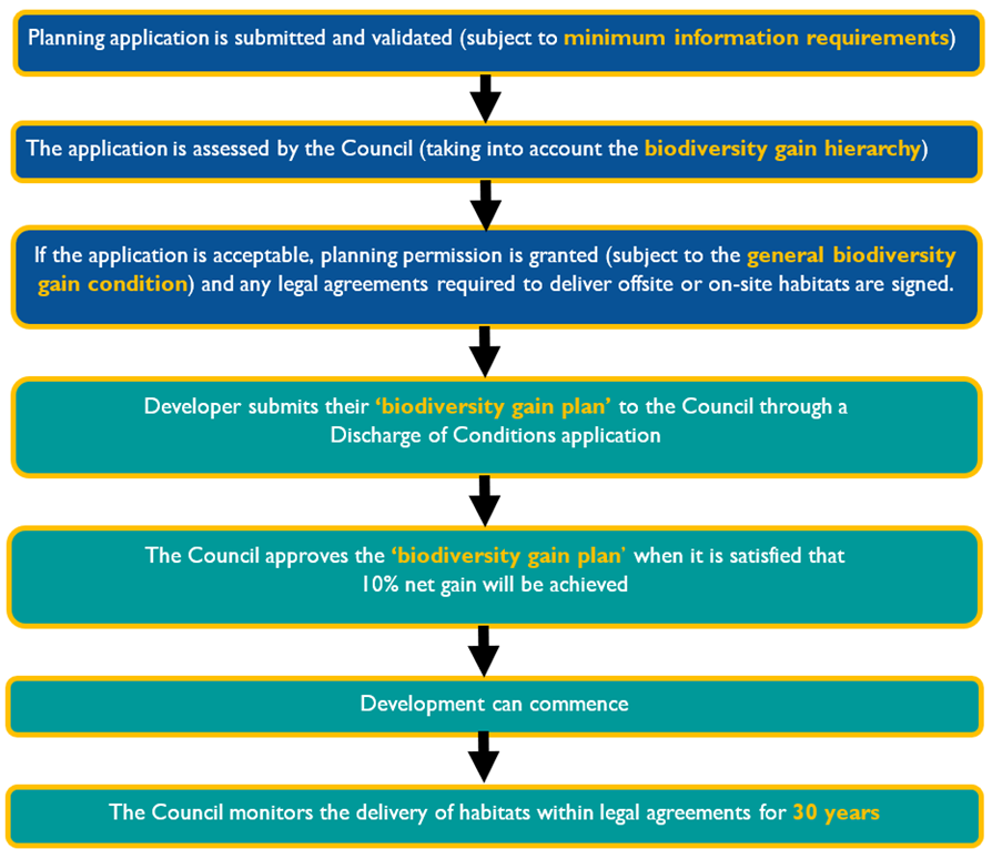
Planning Process Flow Chart image text:
- Planning application is submitted and validated (subject to minimum information requirements).
- The application is assessed by the Council (taking into account the biodiversity gain hierarchy).
- If the application is acceptable, planning permission is granted (subject to the general biodiversity gain condition) and any legal agreements required to deliver offsite or onsite habitats are signed.
- Developer submits their 'biodiversity gain plan' to the Council through a Discharge of Conditions application.
- The Council approves the 'biodiversity gain plan' when it is satisfied that 10% net gain will be achieved.
- Development can commence.
- The Council monitors the delivery of habitats within legal agreements for 30 years.
The Council has produced a guidance note on how to demonstrate a net gain and meet the Council’s BNG requirements, including which types of evidence to provide at different stages of the planning process. It summarises the collection of government guidance (www.gov.uk) and sets out the requirements needed to assess planning applications efficiently. The aim is to minimise delays and costs by ensuring applications are “right first time”.
This guidance document can be downloaded below in PDF format.
Delivering Biodiversity Net Gain in Stafford Borough Guidance Note (pdf 1.7mb)